
You pull out your phone, type in “coffee shop,” and a blue dot instantly shows you exactly where you stand. We use this tech to order rides, track our morning runs, and land commercial jets. It honestly feels like magic.
But behind that glowing dot is a massive, multi-billion-dollar network of atomic clocks and spacecraft, all running on physics theories Albert Einstein mapped it out over a century ago.
If you really want to know how GPS works, you need to look past your screen. Look up. Way up—about 12,500 miles. Keeping you on the right road takes a crazy mix of speed, time, and gravity. If engineers stop actively correcting the system, the whole map goes dark in minutes. Plus, the tech is changing fast. With the launch of the final GPS III satellite in April 2026, the grid tracking you just got insanely sharp.
Let’s cut the heavy jargon and look at the actual science keeping you on track right now.
The Hardware Above Us
To see the big picture, you have to break the system into pieces. It isn’t just a bunch of metal boxes floating in the dark. The Global Positioning System is split into three main chunks that constantly talk to each other.
|
System Part |
What It Is |
What It Does |
|
Space |
32 Active Satellites |
Orbits the planet and blasts radio signals back to Earth. |
|
Ground Control |
Radar Stations |
Tracks the satellites, fixes their orbits, and corrects their clocks. |
|
You |
Phone, Car, or Tracker |
Listens to the signals and does the math to find your spot. |
The Three Pieces
The space side gets all the attention. Out of the thousands of active satellites up there in 2026, the U.S. Space Force keeps a dedicated fleet of 32 GPS satellites running full-time. They sit in Medium Earth Orbit (MEO), roughly 12,550 miles above us. They orbit the planet twice a day in very specific patterns. Because of this layout, no matter where you stand on Earth, your phone can almost always “see” at least four of them.
Down here, ground control runs the show. Master control stations and massive radar antennas track the health of every single satellite. If one drifts off course or its clock ticks a fraction of a second too fast, ground control sends up a fix.
Then there is you. Your phone, your car, or your smartwatch. Your device doesn’t actually talk to the satellites. It strictly listens. It catches invisible radio waves and crunches the numbers.
The Math That Finds You: How GPS Works Through Trilateration
People love using the word “triangulation” when talking about tracking a phone. But that’s actually wrong. Triangulation uses angles. The real secret to how gps works is a math trick called trilateration, which relies entirely on measuring exact distances.
|
The Method |
What It Measures |
How It Finds You |
|
Triangulation |
Angles |
Uses crossing angles from known spots (like cell towers). |
|
Trilateration |
Distance |
Uses overlapping spheres based on radio signal travel time. |
Why Distance Matters?
Imagine standing in a giant field, blindfolded. Someone yells, “You are exactly 10 miles from the water tower!” That doesn’t help. You could be anywhere on a massive 10-mile circle around that tower.
Then, another person yells, “You are 12 miles from the barn!” Now, your water tower circle overlaps with the barn circle. They cross at exactly two spots. You know you are standing at one of those two points.
Finally, a third person yells, “You are 8 miles from the big oak tree!” When you draw that third circle, all three intersect at one single spot. You now know exactly where you are.
This is trilateration. In real life, satellites don’t draw flat circles. They broadcast in every direction, creating giant, invisible spheres of radio waves. Your phone grabs a signal from one satellite, putting you somewhere on that sphere. A second signal creates a ring where the spheres cross. A third narrows it down to two points. One of those points is usually out in deep space, so your phone tosses it out and assumes you are the point on the ground.
Time Equals Distance: The Atomic Clocks
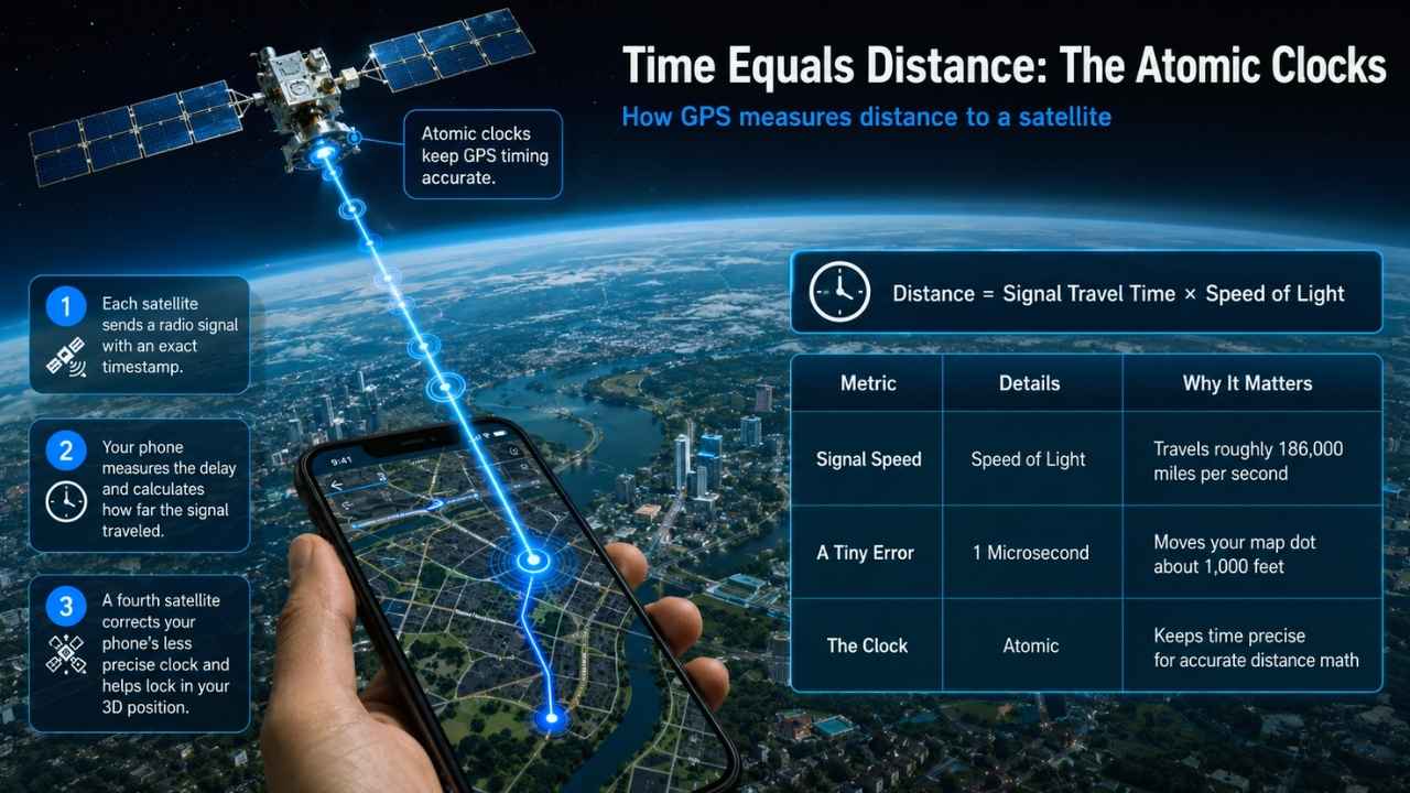
If the whole trick relies on knowing the distance to the satellite, how does your phone measure it? You can’t exactly throw a tape measure into space. The core of how gps works actually boils down to telling time.
|
The Metric |
The Details |
Why It Matters |
|
Signal Speed |
Speed of Light |
Travels roughly 186,000 miles per second. |
|
A Tiny Error |
1 Microsecond |
Puts your map dot about 1,000 feet away from you. |
|
The Clock |
Atomic |
Keeps perfect time so your distance math is flawless. |
Every satellite constantly sends out a radio signal. Tucked inside that signal is a timestamp marking exactly when it left the satellite. Since radio waves travel at the speed of light, your phone just checks the time difference between when the signal left and when it arrived. Multiply that travel time by the speed of light, and your phone knows the exact distance to the satellite.
Because light is incredibly fast, timing is everything. If a clock is off by a single millisecond, your map will think you are 200 miles away.
To stop this from happening, every satellite carries a set of atomic clocks. These measure time using the vibration of atoms. In fact, the newest satellite launched in 2026 carries a digital rubidium atomic frequency standard clock, an experimental upgrade that rarely loses a single second over decades. But your phone just has a cheap, standard clock chip. That is why you need a fourth satellite. The signal from satellite number four corrects your phone’s cheap clock, syncing it up with the atomic clocks in space. Boom. You get your exact 3D location.
Why Einstein Powers Your Map?
You can’t really explain how GPS works without Albert Einstein. If we ignored his theories of relativity, the map on your phone would break in a single day. Reality gets weird when you move really fast or get far away from Earth’s gravity.
|
The Relativity |
The Cause |
What It Does to Space Clocks |
|
Special |
Extreme Speed (8,700 mph) |
Clocks tick slightly slower. |
|
General |
Weaker Gravity (12,500 miles up) |
Clocks tick noticeably faster. |
Einstein’s special relativity says that if you move fast, time slows down for you. Since GPS satellites rip through space at 8,700 miles per hour, their atomic clocks tick slower than the clocks sitting on Earth. They lose about 7 microseconds a day.
But there is a catch. General Relativity says that heavy things—like the planet Earth—warp space and slow down time with gravity. Because the satellites are 12,500 miles away from Earth, they feel much less gravity. That lack of gravity actually makes their clocks tick faster. They gain about 45 microseconds a day.
Subtract the 7 microseconds lost to speed from the 45 microseconds gained by weak gravity, and the space clocks are moving 38 microseconds faster every day than the clocks on the ground. It sounds tiny. But if we didn’t mathematically fix that offset, your map would be wrong by 6 miles by tomorrow morning.
The Massive 2026 Upgrades: GPS III and The Datum Shift
The tech doesn’t just sit there. 2026 has been a huge year for location tracking. On April 21, 2026, SpaceX fired a Falcon 9 rocket out of Cape Canaveral carrying the SV10 satellite. This flight officially wrapped up the massive GPS Block III upgrade project, paving the way for the next-gen “Follow-On” series starting in 2027.
|
Upgrade Feature |
What It Does |
Why It Matters Now |
|
Sub-Meter Accuracy |
Shrinks the margin of error to 1 meter or less. |
Better road directions and pinpoint drone deliveries. |
|
M-Code Protection |
8x stronger against signal jamming. |
Keeps military and aviation signals safe from hackers. |
|
NATRF2022 Datum Shift |
Realigns the entire North American coordinate grid. |
Fixes a 2.2-meter drift in the old mapping system. |
The 2026 Datum Shift
If you work in surveying, farming, or construction, you are likely dealing with the 2026 datum shift right now. The National Geodetic Survey is officially replacing the old coordinate system (NAD 83) with a brand new one called NATRF2022.
Why? Because the old system was off by about 2.2 meters from the actual center of the Earth. A farmer’s tractor using auto-steer on an old boundary map might drift straight into the neighbor’s fence today because the invisible grid shifted. Updating to the new system ensures American GPS perfectly matches global positioning networks.
Read Also: Project Kuiper: Amazon Launches First Internet Satellite Prototypes
Beyond Maps: How We’re Using GPS Today
We are pushing the tech way beyond just finding the nearest gas station. By 2026, location tracking has fused directly with the Internet of Things (IoT).
- Disposable GPS Shipping Labels: We no longer need bulky, expensive trackers. Logistics companies are now slapping ultra-thin, disposable GPS labels onto single pallets. They run on low-power cellular networks (LTE-M) and track a single box from a factory in China right to your front door without needing a battery recharge.
- Bluetooth Handshakes: Modern GPS trackers inside delivery trucks now scan for Bluetooth Low Energy (BLE) tags. The truck knows exactly which packages are loaded inside it. When a driver unloads a box, the GPS notes the exact coordinates and automates the proof of delivery.
- Smart City Grids: Cities are pulling live location data to adjust traffic lights in real-time, clearing routes for ambulances before they even hit the intersection.
You Use More Than Just GPS
While the American system gets the spotlight, it isn’t the only one up there. It is just one piece of the Global Navigation Satellite System (GNSS). Your smartphone rarely relies on just one network anymore.
|
System Name |
Who Runs It |
Active Satellites |
|
GPS |
United States |
~32 |
|
Galileo |
European Union |
~27 |
|
GLONASS |
Russia |
~24 |
|
BeiDou |
China |
~44 |
To get a lock in seconds, your phone chip listens to everyone. If a tall building blocks an American satellite, your phone instantly grabs a signal from the European Galileo network or China’s BeiDou network to fill the gap. At any given moment, your phone is likely pulling data from dozens of the 100+ navigation satellites currently orbiting Earth.
Final Thoughts
Next time you send a pin to a friend or route a road trip, think about the insane amount of invisible tech working above your head. From massive cargo ships crossing the ocean to you finding a late-night drive-thru, how gps works is wild. We took rocket science, smashed it together with theoretical physics, and fit it into a pocket-sized chip.
With the April 2026 launch of the final Block III satellite and the shift to the new NATRF2022 coordinate system, this invisible network is sharper and stronger than ever. The science behind your map proves that sometimes, the most incredible feats of engineering are the ones we can’t even see.
Frequently Asked Questions (FAQs) About How GPS Works
Does my phone need Wi-Fi or cell service to find me?
No. The GPS chip in your phone runs completely on its own. The satellites blast radio waves whether you have internet or not. But, you usually need an internet connection to download the actual street map images so the blue dot makes sense.
Who owns the whole system?
The United States government owns it, and the U.S. Space Force runs it. Even though it is military hardware, they let the whole world use it for free.
Why does my map app suddenly throw me across the street?
City buildings cause a lot of trouble. Radio signals bounce off glass and concrete before hitting your phone. That bounce adds a tiny delay. Remember, a tiny timing error messes up the distance math, tricking your phone into thinking you moved.
Can the government track me using the satellites?
No. The satellites are basically just loud space clocks screaming the time. It is a one-way street. Your phone listens, but it has no way to transmit anything back to space.


